
|
Young - Lort catchment |
| Overview | 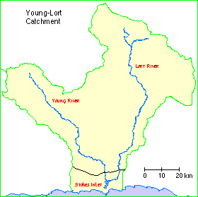 |
Waterways |
The Young - Lort catchment comprises Stokes Inlet together with the catchments of the Young and Lort Rivers and their tributaries plus some of the small creeks, drains and land which drains to the inlet.
Aboriginal and European history
The rivers on the south coast of Western Australia were often used as major thoroughfares by the Aboriginal people as they travelled through the landscape. This is especially true of the inland Esperance landscape, which is semi arid and fairly inhospitable. The Young River has large pools of water, which are permanent through summer. The main water channel is fairly saline but freshwater soaks can be found along its length. These freshwater soaks made the river a popular camping place of the Aboriginal people, with six official Aboriginal sites recorded along the river. Leighton and Watson (1992) also found several stone artefacts along the banks of the Young River, which were brought to the attention of the WA Museum.
Research by Dr. Von Brandenstein in 1988 concluded that a group of Aboriginal people called the "Shell people" lived along the south coast between Bremer Bay and Israelite Bay. These people were divided into two groups: the Wudjaarri in the west and the Nyungarra in the east. The Young River represented the border between the Wudjaarri and the Nyungarra people. An oral history recording made by the Museum of Western Australia tells an Aboriginal story set on the Young River and the Stokes Inlet. The story came from Tommy Bullen of Norseman.
"Walidj bewenerup: once everyone was camped way up the Young River, but the eagle chased everyone away from the freshwater to keep it for himself. Because of his greed, the water eventually all dried up, but in the meantime the eyes of the crows (people) had all turned white because they'd been forced to drink salt water. In the fight that eventuated the crows speared the eagle and killed him. His wife, the mallee hen, brought this body downstream and buried him. His grave looks like a mallee hen's nest all scraped up into a mound. This is the hill on the east side of Stokes Inlet"
Surveyor General Mr J.S Roe on an expedition southeast of Perth named Young and Lort River. The Young River was named after the Governor of South Australia and the Lort River after J.S Roe's good friend Captain J. Lort Stokes, R.N.
Alex and John Moir where the first European settlers to take up land in the area. They were granted a pastoral lease of 7000 acres, each side of the inlet. In 1888, William and George Cheyne were granted a pastoral lease of over 57 000 acres and in the same year built a house at Fanny Cove. It wasn't until the 1950s that agriculture on the Esperance Plains began. In 1949 the original Moir Station was sold to Noel White of Young River Station. The majority of the clearing in the upper catchment was undertaken in the late 1970s.
Climate
This is a fairly low rainfall area, with most rain in winter. Highest rainfall is on the south coast, with an average of around 600 mm. Infrequent unseasonal heavy rain can occur, and floods can be as important to the future of the estuary as the winter rains because of the erosion they cause and the sediment they carry.
Soils and landforms
The catchment rises gradually from behind the coastal dunes to some 250-300 metres at the northern watershed on the south edge of the plateau. The topography is mainly that of rounded and shallow valleys in the northern section and deeper valleys in the south. At the coast a chain of rocky headlands is linked by dunes.
Shallow loamy soils overlie yellow clayey subsoils in the upper part of the catchment, and there is clay to the surface in the northern part of the Lort River catchment. The soils are saline. The southern part has sandy soils, duplex, with sand overlying clay subsoils. Along the coast there are poorly developed sandy soils.
Flora
A mosaic of dense scrubland and sand heath dominates the coastal dune system and coastal plain. The dense scrub to three metres high is mainly a mixture of small Eucalypts and Acacia, with an understorey of Spyridium and Leucopogon. The sand heath on the coastal plain is dominated by Banksia and Lambertia and a diverse mix of proteaceous species. Further north, in uncleared sections, the bushland is a mallee of Eucalyptus, and Melaleuca.
A considerable section of the catchment is the Mallee District, characterised by:
Land use
Although the land near Stokes Inlet has been used for pastoral leases since the mid 1860's, it is only recently (from 1950's) that agricultural development has taken place in the catchment. Most of the cleared land is used for cereal production and sheep grazing, with some beef production near the coast.
The area surrounding the inlet is virgin bush, densely vegetated. The inlet is popular with professional and amateur fishermen.
Wetlands Surveys
The following wetlands in the catchment have been surveyed and "report cards" prepared. The reports are available as PDF files. The locations of the wetlands can be seen on the survey map and in the overall survey report.
Management Reports
Management recommendations:
in Yerritup Stream Condition Report (2004) Steve Janicke [unpublished]
in Discover the Young River - An assessment of condition and values (2008) Andy Chapman
Copies of these reports are available from the Albany office of the Department of Water.
