
|
Albany Harbours catchment |
| Overview | 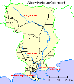 |
Waterways |
The Albany Harbours catchment comprises Princess Royal and Oyster Harbours together with the catchments of the Kalgan and King Rivers and their tributaries plus some of the small creeks, drains and land which drains to these harbours. The total area of the catchment is 312,000 hectares.
Climate
Many climatic measurements in the catchment show a marked variation from south to north, due primarily to the influence of the Southern Ocean.
There is an increasing range in daily and annual temperatures from south to north. For example the average temperature range for Albany is 9.0 - 16.2 °C. in winter and 15.8 - 22.9 °C. in summer. The equivalent values for Mount Barker are 6.6 - 15.3 °C in winter and 13.1 - 26.1 °C in summer.
Rainfall shows a similar marked gradient from over 1200 millimetres. in the south to less than 500 mm. in the far north of the catchment. There is a reversed but less dramatic gradient in annual evaporation from approximately 1500 mm. in the north to 1200 mm. in the south. The humidity shows little large-scale variation from north to south at around 70% in the morning and 60% in the afternoon. About two-thirds of the annual rain falls in the six months from May to October. Seasonal rainfall and potential evaporation dictate the length of the growing season, which varies between seven and ten months in the sub-region.
The winter winds are predominantly westerly and stronger near the coast. Summer winds are more commonly from the east, due to high pressure systems south of the state, with south to south-easterly sea breezes in coastal areas in the afternoon.
Geology, soils and hydrogeology
Gneissic rocks (very old granitic rocks metamorphosed by heat and pressure) underly most of the catchment area, and are exposed in the Porongurup Range and at intervals along the coast. The Stirling Range is composed of metamorphic rocks also formed over 1000 million years ago by the action of heat and pressure on sand and clay sediments. After separation from Antarctica 120 million years ago and a resulting "sagging" of the continental margin, there were periods of erosion and deposition until 40 million years ago when higher sea levels saw the area covered by the sea and marine sediments were laid down. Another southward tilting event 30 million years ago resulted in the formation of the south-flowing Kalgan and King Rivers. Wind, water and chemical erosion since then has resulted in weathered deposits and recent consolidation of sand dunes has formed limestone along the coast.
Most of the catchment is relatively flat and the rocks and their weathered products have low permiability, so in general the southward regional groundwater movement is very slow (less than one metre per year). Locally, in coarser sediments or where steeper gradients exist, for example on the sides of river valleys, the movement will be towards the river and faster.
Much of the soil has poor drainage, with rain-borne salt accumulating in deep soil profiles. Rising groundwater levels caused by the clearing of native vegetation has mobilised these salts.
There is a mixture of soil types in the catchment. There are well-drained gravels and loams in the soapstone country, with sandy gravels and hill soils. Other areas have seasonally waterlogged gravels and loams, with clay and shallow sand over clay. Waterlogged sands tend to be acidic, and peaty sands are very acidic. There are also areas of deep sands, and the catchment has laterite ridges and granite outcrops.
Many of the soils have been formed on highly weathered parts of the sediments, and are very infertile Trace elements have to be added to lateritic soils, and nitrogen has been applied both as a fertiliser and by growing of legumes. Leaching of the soils in the high rainfall areas has resulted in their becoming acidic.
Flora
The flora of the region is a rich and varied jarrah forest. The Stirling Range National Park is an area of high species diversity, particularly for Proteaceae and Epacridareae. The Porongorup Range National Park, which is an outlier of the main karri forest, also has great floral diversity.
The eastern and north-eastern areas are home to mallees and the rich heaths of the sand plains.
Land use
Albany was first settled in the early 1800s, and became the centre for large pastoral holdings. The discovery of gold in the area and government incentives to agriculture resulted in widespread settlement of the catchment by the mid 1800s, and the latter part of that century saw diverse farming and agriculture in the area.
The early twentieth century saw increased timber milling, and the planting of extensive orchards. The area developed potatoes, dairying, pigs and beef cattle as main primary produce. More recently, sheep and cereal have become major land uses.
Wetlands Surveys
The following wetlands in the catchment have been surveyed and "report cards" prepared. The reports are available as PDF files. The locations of the wetlands can be seen on the survey map and in the overall survey report.
Management Reports
Management recommendations:
in Survey of River Foreshores in the Oyster Harbour Catchment WRT 17 (1997) Waterways Commission
in Survey and Management Recommendations for the Foreshores of the Yakamia Creek Catchment (1999) Greenskills
Foreshore survey:
in Foreshore condition of selected lower order streams in the Oyster Harbour Catchment (2001)
and The Condition of the Kalgan River Foreshores 1992/93. Report No 52 (1992/93) Waterways Commission
Copies of these reports are available from the Albany office of the Department of Water.
