
|
St Mary's Inlet |
| St Mary's Inlet at a glance | ||||
| Inlet length: | One kilometre |
|||
| Inlet width: | 250 metres | |||
| Data selection | ||||
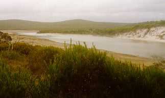
Saint Mary River flows to the inlet in a steep rocky valley with several pools, the last nearly one kilometre long, and discharge to the inlet through a densely vegetated swamp. Small tributary creeks also flow direct to the northern rocky shore of the inlet. The southern shore of the lagoon has narrow sand flats with samphire and other marsh plants backed by paperbark tree against the hill slope.
The sand bar is part of the beach and is only about 1.5 metres above sea level. Waves wash over it and carry sand into the channel shallowing it for about 200 metres from the dune line. The estuary is shallow throughout with the lagoon floor being around sea level. Consequently the lagoon often dries out in the summer months, leaving only a small amount of water in the channel.
Further Information:
South Coast Regional Land and Water Care Strategy: The Fitzgerald-Biosphere Sub-region. Prepared by the South Coast Regional Assessment Panel and the South Coast Regional Initiative Planning Team March 1997.