

November 2001
|
November 2001 |
Local ecologist Andy Chapman and Kaylene Parker from the Water and Rivers Commission, have completed a walk along the Phillips River from the National Park to Mount Madden in the north as part of a foreshore survey to learn more about the river. The foreshore survey has been organised and funded by the Water and Rivers Commission and the Natural Heritage Trust. For more information contact the Department of Environment.

 Sights and sounds of the Phillips River
Cocanarup Road to the South Coast Highway
We began the walk along the Phillips River south of the property that was originally settled in 1868 by the Dunn family. The river corridor here was typical of a river corridor found in an agricultural area. The vegetation condition was graded low B grade to C grade, which indicates that weeds and erosion are common in this area, but that the vegetation is generally in good condition.
A limestone kiln located on the edge of the riverbank was used to burn lime to make mortar to build original homesteads. This site is indicative of the heritage and history of the Phillips River.
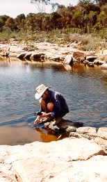
As we moved up towards the highway, the river trickles over a series of granite rocks that stretch for several kilometres and are visible to motorists on the highway. The river is confined to a few shallow but interconnected pools. These river pools are very important as they provide a habitat for birds and also, as Andy discovered, home for some of our native fish species.
The two native fish species we have seen to date include the Swan River Goby, which are present in most pools, and the Spotted Minnow, which is restricted to rocky pools with aquatic plants present. Andy is currently studying the habitat requirements of the Spotted Minnow as part of his Masters degree, and is recording where these fish are found on the Phillips and the salinity levels of these pools. The salinity of some of the pools sampled ranged from the concentration of seawater to almost three times seawater.
 Pools and Pythons
National Park to Cocanarup Road
Day two of our river walk began north of the National Park and ended at Cocanarrup Road - a 16 kilometre stretch of the Phillips River. The walkers included flora and fauna consultant Angela Sanders and Annie Brandenberg, manager of the South Coast Regional Initiative Planning Team (SCRIPT).
 The river was in A grade condition except for one section where the grading dropped to B grade due to extensive weeds in a flood-damaged section. Generally, the weeds were only found along the main channel due to recent floods. It is likely that the native vegetation surrounding the river will gradually overcome these weeds. The amount of box thorn present along some sections of the river is a concern.
Along the walk, Andy and Angela recorded the bird species encountered. Thee rare and endangered species were seen including a Mallee Fowl, Carnaby Cockatoos and Western Whipbird. Over the 16 kilometres 35 bird species were recorded. A python (also rare and endangered) was seen slowly moving through a box thorn, and two dugites also kept us on our toes, especially as Andy reached to get his water quality monitoring equipment, and was surprised as it moved!
Once again Andy recorded the location of pools containing some of our native fish, the Spotted Minnow and the Swan River Goby. A couple of pools had "fish kills" with up to 20 dead fish. It is likely that these fish died as the salinity levels increased due to evaporation, or due to high temperature and low oxygen level changes. Andy recorded these parameters to help provide more information on the habitat requirements of our native fish.
A few more river pools were seen in this section of the walk and ranged from a couple of centimetres to 1.5 metres deep. A macrophyte (grass-like aquatic plant) known as Ruppia was seen in these deeper pools. This species is an important food source and home for some of our native fish and water bugs. Along the way we came across the site of the old "Pick and Shovel" gold mine. The old diggings are still very evident.
The grave site of John Dunn was seen near the end of our walk, a reminder of the historical importance of this river and the land surrounding it.
 Of granite and freshwater
Phillips River Bridge and Aerodrome Road
Today's walk covers a distance of 10 kilometres. It is a community walk with 11 adults and five children starting out on a warm Sunday morning.
The first unusual encounter was with numerous freshwater soaks in the sand of the river bed. These aroused much interest as we had not encountered them previously on the Phillips; their presence is usually indicated by numerous kangaroo tracks leading to them. Closer examination usually reveals tadpoles and frogs which are not present in the more saline river pools; often there are different plants as well, including the well known Aboriginal food plant Nardoo.
After about two hours walking we came to an extensive area of granite outcropping where the river had forged its way through a large granite outcrop to make a small gorge. Here there were granite rock holes - also with good quality fresh water. Two of these had been drilled and blasted to increase the water holding capacity. It was here that while stopped for a spell we were treated to the mournful distress call of a spotted-thighed tree frog as it disappeared down the throat of a racehorse goanna - tough on the frog but that is nature.
The river along this stretch is in fairly good condition, partly because it is buffered by timber reserve to the west and a narrow river reserve to the east. In spite of this, many weeds were recorded some no doubt due to the recent flooding. The effects of the flood here include large plumes of sandy sediment which either suffocate the saltwater paperbark vegetation or it becomes up rooted by the force of the current.
Two different kinds of fish and 36 kinds of birds were recorded along this section of river.
By mid morning it was quite hot so we all strode out for Aerodrome Road, where a welcome cold drink and sausage sizzle lunch provided by the Water and Rivers Commission and served up by Alan Carmichael and Lynda Steele was enjoyed by all. It took almost exactly six hours to cover the ten kilometre distance.
 Of salinity and survival
Aerodrome Road to Bridger
This day's walk began at Aerodrome Road, and finished at Bridger Road, and was completed with the assistance of local residents Pam Chapman, Peter Denton and Alan Carmichael.
 One of the consequences of the Phillips River flooding in January 2000 was that yabbies from farm dams were washed into the river. These took up residence in relatively fresh water pools with sufficient depth and suitable food sources. Many of these pools are now dry or very saline, and the yabbies obviously could not survive this. Five yabbies were found in one small pool partly fed by fresh groundwater that were still alive - but only just. The salinity was 42 units (seawater is 52 units) and there was plenty of oxygen in the water. From this, you could assume maximum salinity levels that the yabbies could tolerate been reached.
Further upstream we had the opportunity to examine a similar situation with a native fish - the Spotted Minnow. Three pools between Dam and Bridger Roads contained dying fish, with salinity readings between 75-90 units. Once again because oxygen was sufficient in the water, you could assume that these fish were at the limit of their tolerance. But things in nature are not always straightforward, and maybe the higher water temperature is also a factor causing their death. Many other pools along this section of the river were monitored and most were hypersaline with salinity levels ranging up to 184 units. These pools obviously had no fish.
This section of the walk also revealed that most of the vegetation along the banks is in A class condition; this is not to say that it is pristine as this is very seldom the case in any river in south coast. However there is one small section where stock access has been too close to the river and the understorey vegetation has been changed from shrubs to introduced grasses.
Another interesting aspect of the river was revealed in this section. In numerous sites between Dam and Bridger Roads the exposed rocky river bed is intersected by dolerite dykes. At these sites there are active saline seeps into the dry river. While each seep is relatively small, the combined effect results in a small trickle of highly saline water which finds its way to the nearest pool. Through evaporation, the salt then precipitates out to form a crust of salt resembling snow. This is possibly one reason for the maintenance of the salinity in the Phillips River.
 Saline pools and revegetation
Fitzgerald Road to north of Mount Madden
In the upper catchment, the Phillips River fans out into a broad valley, not looking like a river as you would imagine. In fact, there is little evidence of water except in white and pink saline pools, or if you dig a hole. North of the Lake Grace Road is the only section of the Phillips River in private ownership.
As groundwater seeps from the catchment into the lowest part of the landscape, the river, it evaporates leaving the salt remaining in the riverbed. This is a natural process, in a salty river system and a naturally salty landscape.
In the upper catchment, it became evident the amount of work that landholders had done to protect the river. From the top of Mount Madden, there was a green corridor of revegetated foreshores almost to the Lake Grace Road. This included salt bush, tall wheat grass, Melaleuca species, yates and acacias. This has helped to protect the river channel during the last floods. The vegetation also uses some of the moisture remaining in the soil and has a draw down effect on the rising groundwater levels. The ecological value of the vegetation is also evident by the sound of birds we could hear using the river corridor.
There is however evidence that rising groundwaters are beginning to impact on the condition of the river. Melaleucas have died in some sections and the vegetation is changing to a sandphire-dominated community. There is also evidence of salt scald creeping up into the adjacent paddocks.
The challenge to protect the river in the upper catchment is to minimise the amount of water draining into the river in order to stop the groundwater levels rising, and the expanding basins of salt spreading up into the paddocks. This means using water higher up in the landscape - perennial pastures, summer crops, surface water management, longer season growing crops and other sustainable farming practices that we need to implement over the long term. This is currently very challenging in a non-favourable economic climate.
Beyond the Survey
As we climbed the top of Mount Madden to look down at the Phillips River curling off into the distance, we reflected on the changes that the river undertakes from the top to the bottom.
A river system that begins in an agricultural landscape, where crops grow alongside saline river valleys. To the river that forms a channel through granite rocks, with fresh water soaks. To a river that becomes a series of interconnected pools, trickling over extensive areas of granite, finally down to Culham Inlet, where the river finally meets the ocean (twice in recorded history). It is a river that forms part of our culture and history - grave sites, mine sites, lime kilns. Finally, a river of ecology - native fish, aquatic plants, birds and water bugs.
With the survey complete, it does not end there. Landholders throughout the catchment are continually working to improve the productivity of their farms - through no till, improved cropping regimes, surface water management and appropriate fertilizer use. Many are looking after the land to look after the river. They are also fencing tributaries throughout the catchment and are revegetating degraded areas. This is all helping to protect the unique Phillips River.
In addition to this, the Department of Environment will be developing an Action Plan in cooperation with the Ravensthorpe LCDC to help ensure the on-going protection of the Phillips River for future generations. The survey and Action Plan can then be used as a tool to get further funding for on-ground works.
The "Walk" will also be incorporated into a visual CD and pamphlet that can be used by community members, landholders and school children, so that we can easily "walk" and learn about the river.